--The BEST Outdoor INFORMATION in the Southeast!--
# 4 - The Jungle
Rated: Moderate
4 - 6 miles, round-trip
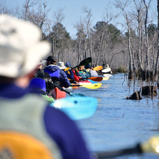
The Jungle is an enclosed tupelo swamp with an
appearance like the famed Okefenokee Swamp of
south Georgia, but on a much smaller scale. The
waters are heavily grown with water lilies, lotus
plants and various tall aquatic grasses. There are
many options for exploration and large birds of prey
(egrets, bald eagles) are common on this paddle.

Difficulty: Moderate.
Distance: 4 - 6 miles, round-trip, opportunity for a lot more exploration.
Time: 2.5 hours, minimum.
Crowds: Very light. The Jungle is not navigable by larger motorboats.
Put In / Take Out: Amos Lee Gourdine Boat Ramp, Russell Store Road, St. Stephen, SC 29479. GPS: 33.402138, -79.992848 or 33°24’07.7”N, 79°59’34.3”W. PHOTO of BOAT RAMP.
Fees/Permits: None.
Current: Negligible, generally northeast direction in open water.
Tidal Influence: None.
Trees Down or Other Obstructions? If you come across downed trees, limbs or other obstructions while paddling
this blueway, please let us know. We can often facilitate removing it. Contact us at 843-433-0361 or 843-719-4146.
Precautions: You’ll stay close to the shoreline on this route. Winds can intensify on Lake Moultrie resulting in waves/whitecaps. There are hundreds of tree stumps just inches below the water’s surface, particularly the closer you get to the entrance of The Jungle. These can flip a paddler if a boat gets wedged on top. Pro Tip: these stumps can usually be seen with polarized sunglasses.
Water Level: For this Blueway paddle trail, in order to explore most of the back areas of The Jungle, water levels above 75.00 are best. Lake Moultrie Water Levels click HERE.
So Much History Nearby: Did you know Berkeley County has more than 110 historical markers and historical points of interest? CLICK HERE to find your Adventures in History!
Weather on the Trail: Click HERE


